Some Local Kerry Towns In alphabetical order
) is a village in County Kerry, Ireland, located on the Iveragh peninsula on the Ring of Kerry. It is on the southwestern side of the peninsula, facing onto Derrynane Bay.
In February 2010 a mountain fire endangered many homes and destroyed mountain wildlife. The Fire Brigade brought it under control after many hours. There have been several recent sightings of the white-tailed eagle, lately reintroduced to Kerry.
Three km to the north, on Carrigafoyle Island, stands the castle and anchorage commemorated in the name of the village. For centuries, Ballylongford shared the political, military and religious fate of the castle and the nearby Franciscan Lislaughtin Abbey.
The village of Caherdaniel is beyond Westcove, near Derrynane Bay is St. Crohane, hewn out of solid rock; about a mile (2 km) away is an ancient stone fort, similar in construction though smaller than Staigue. Near by Derrynane House, with its historic park, was once the home of Daniel O’ Connell, the ‘Liberator’ who lived and worked there during his political life. The house, now excellently restored, contains a museum with O’ Connell’s personal possessions and furniture. It is open to the public all year round.
Camp Village
Camp is a small, compact village in a beautiful scenic area near the foot of the Slieve Mish Mountains and close to views of the sea, Brandon mountains, Tralee Bay, and Kerry Head. The Camp area is central to the Dingle Peninsula on either side, with close proximity to a number of good, safe, sandy beaches. Tralee is only 16km to the east and Dingle Town is only 32km to the west camp is an ideal getaway resort.
Castlecove
The village of Castlecove is located on the southern part of the Iveragh peninsula halfway between Kenmare and Caherciveen. It lies at the foot of the McGillycuddy Reeks mountain range, and the waters of the Kenmare Bay make the southern boundary. The famous Ring of Kerry passes through the village. Staigue Fort, one of the best examples of a Iron Age fort, is a short distance from the village, and there are many other Ring Forts. The Castle and St. Crohans Cave are just two more fascinating historical sites in castlecove. There are plenty of walks to take, the Kerry Way passes through Castlecove linking Sneem and Waterville, and there are tracks through the hills to explore.
Castlegregory
The village is located at the foot of a sandy peninsula called the Maharees separating Brandon Bay to the west from Tralee Bay on the east. Off the peninsula are a number small islands, called the Seven Hoggs, or the Maharee Islands. Castlegregory town is a animal and bird sanctuary.
Castleisland Town
Castleisland town was once the impregnable Kerry headquaters of the Earls of Desmond: from here they ruled North Kerry. Today, although only scant ruins survive of what was once a formidable powerbase, strong farming markets and good commercial activity gives Castleisland new life. Nearby Crag Castle is fast becoming the great showcave of Ireland. North are the Glanruddery mountains while the Stacks rise gently to the west. Castleisland is an important road junction in this Vale of Tralee, while Kerry’s county airport at Farranfore is just down the road. From there, daily flights connect Kerry with Britain and the major Irish cities.
Castlemaine
Castlemaine is a small town at the eastern end of the peninsula, on either side of the River Maine. Situated at the junction of roads to Killarney, Tralee and Castleisland it is close to all of the county’s attractions, and within a few miles of Kerry Airport. It has all the facilities one would expect: shops, post office and pubs.
Castlemaine is situated on the beautiful Maine River. It was here the Australian outlaw, known as the Wild Colonial Boy was born. He is celebrated in a song of the same name. Castlemaine is perhaps best known internationally as the birthplace of the protagonist in tne Irish/Australian ballad The Wild Colonial Boy. There are several versions of the song, but the first verse as usually heard in Ireland
Cloghane Village
The Cloghane/Brandon area is located on the northern tip of the Dingle Peninsula in the parish of Castlegregory. The villages are set in a semicircle of mountain peaks and overlook beautiful Brandon Bay. This is a Gaeltacht region, where the Irish language is spoken by everyone, an area rich in language, music and dance. The area has an abundance of flora, with arctic alpines growing near the peaks of Mount Brandon, and many seaside flowers growing on the sandy shores of the bay. Cloghane/Brandon has received a Beatha Environmental Quality Award which shows that this area has an excellent environment.
Dingle Town
Once cited as ‘the most beautiful place on earth’ by the National Geographic; was voted among the top 100 destinations in the world.
[caption id=”attachment_5358″ align=”alignleft” width=”150 Dingle Slea Head Drive, Dingle, Ireland
Dingle is the main town on the Dingle Peninsula, the westernmost point in Ireland. It is just big enough to have all the necessary services for tourists, and a steady night time beat for Irish traditional music.Dingle is traditionally Irish, being in theheart of the Chorca Dhuibhne Gealtacht. The main industries here are farming and fishing.The harbour is always busy with fishing boats and yachts, and its few streets are lined with brightly painted shops, pubs and restaurants. In 1970, Dingle was introduced to the world through the film Ryans Daughter, and Dingle fans from all over the world flock to the small town every year. In the 1990′s, the town has gained fame in the world of music, history, gastronomy, scenery and not least it’s friendly dolphin.
Dunquin
Dún Chaoin, meaning “Caon’s stronghold”, is a Gaeltacht village in west County Kerry, Ireland. The Blasket connection has not been without controversy. The huge interpretative centre that opened here in 1993 met initial opposition but was welcomed by the islanders and has since prospered. It celebrates all aspects of the Blaskets, including remarkable and ongoing connection with Springfield, Massachusetts, to which town so many of the islanders emigrated. Among the many spirits that hang about Dunquin are those of Spanish sailors; the ill-starred Armada lost two ships. A monument in the village recalls those who perished.
Farranfore Village
Home to Kerry’s international airport it connects the county with Dublin each day and with Luton and Manchester in England as well as accommodating a series of charter flights.
Fenit Village
About 8 miles (13 km) west of Tralee is a small port on the bay, Fenit. St Brendan, patron saint of Kerry and famous as Brendan the Navigator (484-577), who , it is suggested, may have discovered America, was born in the neighbourhood. Near the village is a glacial erratic, a large boulder of sandstone resting on limestone near the water’s edge. A natural limestone cave at Lissodigue, 3 miles (5 km) to the north-west, can be explored for over 700 feet. Fenit Castle ruin, on Fenit Island 2 miles (3 km) from the village, was built to guard the entrance to Barrow Harbour, which at one time had a considerable trade with Spain and the Low Countries.
Glenbeigh
Glenbeigh or Glanbehy (Irish: Gleann Beithe, meaning “valley of the Birch trees”) is a location in County Kerry, southwestern Ireland. The the area is on the Iveragh peninsula, which is is the largest peninsula in southwestern Ireland. The parish and is home to Rossbeigh Beach, Glenbeigh Towers, Coomasahran Lake, Rock Art, the Natterjack Toad and Kerry Bog Pony. .
Owing to its natural heritage, history and its location on the Ring of Kerry, Glenbeigh is a popular tourist destination. .
Glenbeigh is a place often referred to as “The Jewel in the Ring of Kerry”. It is cosily tucked in to the surrounding horseshoe of hills and Seefin Mountains. The Caragh River and the Behy River flow at either side of the village into Castlemaine Harbour.
Glenbeigh is a very popular holiday base nestled at the foot of a well-wooded mountain and close to the head of Dingle Bay. For a closer view of the magnificent amphitheatre of mountains known as the “Glenbeigh Horseshoe”, one should follow the Glen of the River Behy up to the Tarn from which the river takes its origin. On the Killorglin Road prior to reaching Glenbeigh, the Bog Village Visitor attraction is worth a visit.
Glencar
Located at the foot of Carrauntuohill Mountain and at Kerry Way is Glencar Ireland.
Glencar county kerry is a remote area with lots to give for mountain bikers and hikers alike.
Glencar county kerry boasts magnificent views of Carrauntuohill the highest mountain in Ireland, second to none.
Glencar has rugged beauty of this district is greatly enhanced by the delightful forest at Lickeen. The upper Caragh River flowing through Glencar has always attracted the keenest of anglers, and is also a delight for the hill walker, mountain climber and nature lover.
Inch
Inch is clean, safe and sandy beach ideal for family outings, sandcastle building, and swimming. The long white snad bar which is Inch Strand is spectacularly beautiful. Some 1.5km along the beach, at a break in the sand dunes, are signs of early sandhill dwellers.
Kells
Kells is a small picturesque seaside area halfway between Glenbeigh and Cahersiveen. Traveling from mountain stage Glenbeigh to Kells Post Office one has a panoramic view of Dingle Bay, the Blasket islands and Kells Bay.
You will pass the tunnels at Drung hill and the Gleensk Viaduct, a relic of the Great Southern and Western Railway Line, which ran from Cahersiveen to Farranfore Junction, presently being develop as a cycle route.
Kenmare
Kenmare (Irish: An Neidín, meaning “the little nest”) is a town in the south of Kerry. The name Kenmare is the anglicised form of Ceann Mara meaning “head of the sea”, referring to the head of Kenmare Bay.
The entire area was granted to the English scientist, Sir William Petty by Oliver Cromwell as part payment for completing the mapping of Ireland, the Down Survey in 1656. He laid out the modern town circa 1670. Like William Petty, a previous surveyor of Ireland (1584), Sir Valentine Browne, ancestor of the Earl of Kenmare was granted some lands in County Kerry during the resulting plantation, the Munster Plantation.
The area has more ancient roots. One of the largest stone circles in the south-west of Ireland is close to the town, and shows occupation in the area going back to the Bronze Age (2,200-500 B.C), when it was constructed. The circle has 15 stones around the circumference with a boulder dolmen in the centre
Kenmare has a long and varied history dating from the stone circles adjacent to the town which dates from 2200 – 500 B.C. Kenmare, owned by the Lansdowne Family, became a model estate town in the 18th century, built to a distinctive X-pattern street plan, which is still clear today. There are many unique facts about the town including the very distinctive Kenmare lace. In fact the great art of lace making is still demonstrated in the Heritage Centre building, and antique Kenmare lace is on exhibition in the centre.
Kilgarvan Village
Kilgarvin is situated on the Roughty River, just outside Kenmare. Just off the Kenmare road is a geological oddity, a mushroom shaped rock, formed by a block of sandstone on a limestone plinth.
Killarney Town
Killarney (Irish: Cill Airne, meaning “church of sloes”) is a town in County Kerry, southwestern Ireland. The town is on the northeastern shore of Lough Leane, which is part of Killarney National Park. The town and its hinterland is home to St Mary’s Cathedral, Ross Castle, Muckross House and Abbey, the Lakes of Killarney, MacGillycuddy’s Reeks, Purple Mountain, Mangerton Mountain, the Gap of Dunloe and Torc Waterfall.
Owing to its natural heritage, history and its location on the Ring of Kerry, Killarney is a popular tourist destination. .
Killarney is a place often referred to as “The Jewel in the Ring of Kerry”.
Killarney, Heaven’s Reflex, is the tourist capital of Kerry, and the second most popular tourist destination in Ireland. World famous for it’s national park and lakes, Killarney is also rich in historical houses, castles and monuments. Some of these include Muckross House, Ross Castle, Muckross Abbey and Inisfallen Island with it’s monastic ruins. The town itself is a lively hub of activity, with many hotels, restaurants, pubs, discos, along with outlets for renting bikes, cars and the famous jaunting cars. It is an ideal base for touring West Cork, the Ring of Kerry, Dingle and Tralee. Well serviced by transport – bus, train, and the nearby Kerry Airport, Killarney is easily accessible from Ireland and abroad.
Killorglin Town
Killorglin (Irish: Cill Orglan) is a town in Mid Kerry, Ireland. It is located on the river Laune. Killorglin hosts Puck Fair for both visitors and returning emigrants.
Every year, starting on 10 August, Killorglin holds the three-day Puck Fair, the oldest traditional fair in Ireland. It is a substantial source of revenue and business for the town as a large influx of people descends upon the town each year for the festival. .
Killorglin is a major activity centre for Kerry and has a number of tourist accommodation venues.
Killorglin is a gateway to the beautiful Iveragh Peninsula situated on a hill overlooking the wide and graceful River Laune, a river offering salmon and trout angling. Dominating the landscape to the south are the MacGillycuddys Reeks. This is a good holiday base for touring, and Killorglin is the location of the famous “Puck Fair” festival – Ireland’s largest and the world’s oldest business event.
Listowel Town
The town boasts an attractive market square with the remains of Listowel Castle overlooking the river Feale. Adjacent to the Castle is located the Kerry Literary and Cultural Centre. Seanchai, located in the 19th Century Georgian House in the Square, Listowel celebrates the unique literary tradition of the Region through an interactive audio-visual exhibition on the writers of North Kerry – John B Keane, Bryan MacMahon, Brendan Kenneally, Maurice Walsh and George Fitzmaurice. The exhibition also features the annual literary festival, Writer’s Week and describes the history of storytelling through the ‘Seanchai’, and how this evolved into the art of writing. The Centre also hosts an archive room, a book and craft shop and a literary cafe.
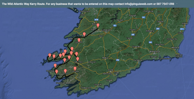
Ring Of Kerry
[caption id=”attachment_75″ align=”alignleft” width=”300 Ring of Kerry Ireland in red
Ring of Kerry (or Iveragh Peninsula to give it its correct name) is a tourist circuit and part of the beautiful & spectacular region of Ireland that has attracted visitors for thousands of years. Its beauty is beyond question and it is a natural centre for outdoor pursuits that include golf, mountain climbing, watersports, cycling, walking, running, riding and the very best of fishing in freshwater rivers for salmon & trout and at sea for pollack, eel, flounder, mullet, mackerel amongst others.
Ring of Kerry has some of the Europe’s finest beaches, Rossbeigh that provide all the facilities for a traditional seaside holiday. Above all, the Ring of Kerry provides an amazing insight into the ancient heritage of Ireland – see the Iron Age Forts & Ogham Stones, Old Monasteries and a landscape carved out of rock by the last Ice Age 10,000 years ago. Visitors to Ireland should not miss a trip to the beautiful Ring of Kerry
Ring of Kerry is a group of local towns said to be the most beautiful place in the World.
The Ring of Kerry takes in part of South Kerry, and it affords a panoramic journey through some of Kerry’s most outstanding scenery around the Iveragh peninsula. The route travels through Killorglin, by Caragh Lake, and on to Glenbeigh where one gets the first view of the Atlantic at Rossbeigh. The journey then continues along the southern shores of Dingle Bay to Kells, and south to Cahersiveen, where Valentia Island comes into view. The Skellig Experience Centre is located here and Ballinskelligs is not far away. Onwards to Waterville and along the coast via the Coomakista Pass and Derrynane to Sneem. From there, along Kenmare Bay to Kenmare town. The route then goes to Killarney via Moll’s Gap and Ladies View which give superb views of the Lakes.
Sneem Village
Sneem is a town situated on the Iveragh Peninsula in County Kerry in the southwest of Ireland. It lies on the estuary of the River Sneem. National route N70 runs through the town.
The Irish town name, “An tSnaidhm”, means “The Knot” in English
Sneem village comprises two squares, North and South. A bridge in the middle of the village, viewed from overhead, acts as a knot between the two squares. A less common explanation is that Sneem is the knot in the scenic Ring of Kerry. The book about Sneem, The Knot in the Ring, recounts the area’s history. In 2000, a time capsule was buried in the centre of the town.
Sneem village has two market squares. Each house and shop seems to be painted a different bright colour. There are a selection of sculptures to be foundhere as well as memorials and a lovely church.
Tarbert Town
Tarbert is situated on a pretty slope overlooking one of the prettiest parts of the Shannon; from here the Shannon car ferry crosses to Killimer, County Clare, every hour on half-hour. The ferry service provides the opportunity for several attractive circular tours. The 20-minute crossing saves 85 miles (137 km) on the same journey via Limerick. Tarbert House, completed about 1730, has a fine collection of Georgian furniture, including the best example of an Irish Chippendale mirror. the house is open to groups by prior arrangement.
Tralee Town
Tralee (Irish: Trá Lí, meaning “strand of the Lee (river)”) is the county town of County Kerry in the south-west of Ireland.
The town is on the northern side of the neck of the Dingle Peninsula, and is the largest town in County Kerry .
Tralee is the county town of County Kerry in the south-west of Ireland. The town is on the northern side of the neck of the Dingle Peninsula, and is the largest town in County Kerry.
While Killarney is the tourism capital of Kerry, Tralee is known as the working capital of Kerry it is the true leading town of the county. Famous worldwide for it’s Rose festival in August, Tralee is a large town of around 20,000 inhabitants. It is well serviced by transport – rail, road, air (Farranfore Airport), and is in ideal base for touring the Dingle Peninsula and the Ring of Kerry. Some of the attractions in Tralee include Blennerville Windmill, Kerry the Kingdom Museum, Siamsa Tire Theatre and the Aqua Dome.
Valentia Island
Valentia is an island of unique scenic beauty, tropical vegetation, breathtaking cliffs and magnificent seascapes. The island is an excellent centre for sea angling and diving in unpolluted waters. The bridge was built at Portmagee in 1970. The island, about 11km long by 3km wide is one of the most westerly points of Europe. The surface is bold and rocky, two prominent features being Geokaun Mountain 268 meters on the north and Bray head 180 metres on the south, both are splendid vantage points for the sightseer. The Skellig Experience is located here. This is where the story of the Skelligs is told. The themes include the monastic settlement, the lighthouse, the bird and underwater life.
Ventry Village
Ventry village is situated about 6km west of Dingle town. It has a beautiful crescent shaped beach, which has watersports in the summer. Legend has it that it was at this beach that the armies of the King of the World and Fionn Mac Cumhaill fought a bloody battle for a year and a day, ending in a draw. The beach is a blue flag beach, and is usually safe for bathing and paddling. Ventry has two pubs, a post office and a small church, as well as a pottery shop and cafe.
Waterville Town
Waterville, historically known as Coirean, is a village in County Kerry, Ireland, on the Iveragh Peninsula.
Waterville, historically known as Coirean, is a village in County Kerry, Ireland, on the Iveragh Peninsula.
Waterville is a picturesque little village overlooking the Ballinskelligs Bay and uniquely, nestled on the beautiful Lake Currane which is best known for the the best Salmon & Sea Trout in Europe..
Waterville, famous as an angling centre, also has much to offer the general tourist. There is a fine sandy beach on the shore of Ballinskelligs Bay, and boasts a championship golf course(18). Around Waterville The town is on the eastern shore of Ballinskelligs Bay, on a strip of land that separates the sea from Lough Currane, one of the most beautiful lakes in Ireland and a great fishing centre. The little Irish-speaking village of Ballinskelligs is charmingly situated on Ballinskelligs Bay: its attractions include boating, bathing, fishing and fine coastal scenery. A beach outside the village stretches for 4 miles (6km). A little to the west are the ruins of an ancient castle of the McCarthys, and of an ancient abbey.